Follow your ears! Yes, there was a time when aural senses were vital to location and geography. In the spirit of resurrecting that spirit, Spencer Kiser’s projects look at new ways of mapping using sound. Full details on his thesis page, but in brief:
Sound maps: Field recordings in Forest Hills, Queens (outside Manhattan) are overlaid with an interactive map of the area. Upshot: drag with your mouse, and you can hear how the sound changes from one intersection to another, rather than just look at the usual visual representation.
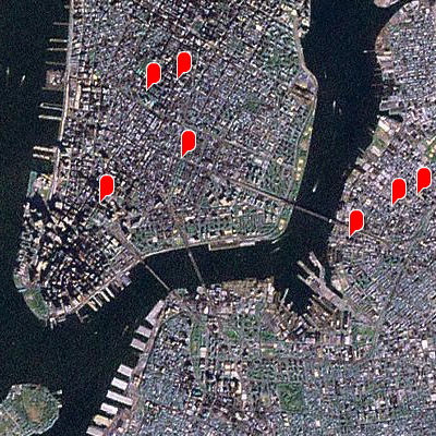
Geo-tagging with a phone: This “participatory sound map” (shown below) lets you dial in the soundscape of different locations (here, again, NYC). Vocal representations get the emphasis here; I can see non-abstract applications, like different pizzerias explaining their handicraft, or finally a detailed map of how accents change in the five boroughs of New York. (And yes, locals can tell the difference between someone from downtown Brooklyn and Flatbush, let alone the Bronx and Queens. Now us outsiders can practice.)
Guided by Voices: Wireless headphones lead you through an installation . . . hmm, too bad this isn’t Halloween season, or this could’ve gotten a bit more macabre.
This should give some ammunition to those of you who like using field recordings in your music. Now remix your geo-tagged sound recordings, and you’ve got a musical application for GPS devices, Yahoo Maps, and cell phones . . . why not? And it’s a good reason to listen to where you are; that iPod battery was probably going to run out anyway.